Ask about our program and pricing for Matterport Pro3 commercial property scanning and tours!
Millions of square feet of commercial property scanned!  Over 1 Million visitors to our Matterport scanned properties!   We provide experience and quality for all your Matterport work.

Real Estate

Real Estate

Save time and offer convenience with residential and commercial 3D virtual tours. Instantly showcase listings to a global audience with remote measurement and management tools.

Learn More
Industries

Industries

Showcase locations directly to millions of Google Maps & My Business viewers globally. Allow viewers to walk through locations directly via 3D tours.

Learn More
Educational Institutions

Educational Institutions

Distinguish your school, university or learning center with remote showcasing technology. Prospective students and families experience 3D virtual open houses of any campus or building. 

Learn More

Why RealTView?

RealTView Technologies. The company was founded in 2009 and has clients all over the world. RealTView offers High-quality HDR Photography, Full Motion Walk-Through Videos, and Immersive 3D Virtual experiences for their virtual tours.

We provide professional real estate photography services to help create gorgeous virtual tours and website images.

In summary, RealTView is a company that provides 24/7 virtual tours and open houses for businesses and real estate using 3D technology and photography services to create virtual tours and website images.

AH Only removebg preview 2

Our Business
Virtual tours are becoming increasingly common in the real estate business, and RealTView specializes in providing them. RealTView uses 3D technology to create 24/7 virtual tours and open houses for businesses and real estate, allowing viewers and customers to see properties from a different perspective. We offer a one-stop shop for 3D Virtual Tours, Google Maps Integrations, 2D Photography and Floor plans. RealTView is a national licensed provide.

REALTVIEW

U.S. National Coverage With 120+ Capture Experts

Image

Contact REALTVIEW

We are here to answer any questions you may have about our products and services. Reach out to us and we will respond asap. If you have any special requests, we will do our best to find a solution that meets your needs.

0
Showcase Locations Directly to Millions
0
Team Effort ON EVERY PROJECT
0
Satisfaction Guaranteed

RealTView

More about realTView

The demand for immersive and interactive visual experiences has led to groundbreaking innovations in various sectors. Among these innovations, realTView 3D scans emerge as a transformative technology, offering unparalleled advantages in real estate, industries, and educational institutions.

Understanding realTView 3D Scans

RealTView 3D scans represent a cutting-edge approach to visualizing physical spaces with remarkable precision and detail. By employing advanced scanning techniques such as LiDAR (Light Detection and Ranging) and photogrammetry, realTView captures spatial data and generates highly accurate 3D models. These models faithfully replicate real-world environments, allowing users to explore and interact with spaces remotely.

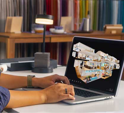
Applications in Real Estate

In the realm of real estate, realTView 3D scans revolutionize property marketing and sales efforts. Prospective buyers can take virtual tours of properties from the comfort of their homes, gaining a comprehensive understanding of layout, design, and spatial flow. Additionally, realTView scans provide precise floor plans and measurements, facilitating informed decision-making for both buyers and sellers.

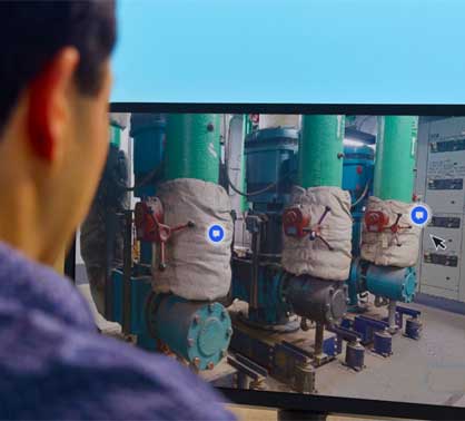
Applications in Industries

Industries harness the power of realTView 3D scans to streamline operations and enhance productivity. From manufacturing facilities to warehouses, these scans facilitate accurate spatial planning and optimization of resources. Moreover, real-time monitoring and analysis capabilities empower businesses to identify inefficiencies and implement targeted improvements swiftly.

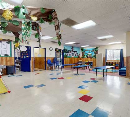
Applications in Educational Institutions

Educational institutions leverage realTView 3D scans to create immersive learning environments and enhance educational experiences. Students can explore historical sites, archaeological artifacts, and scientific specimens in unprecedented detail, fostering engagement and understanding. Furthermore, campus administrators utilize realTView scans for efficient facility management and renovation planning.

Future Trends and Innovations

Looking ahead, the future of realTView 3D scans is marked by continuous innovation and integration with emerging technologies. Advancements in augmented reality (AR) and virtual reality (VR) promise to elevate the immersive experience to new heights. Furthermore, AI-driven enhancements will enhance the accuracy and efficiency of realTView scans, unlocking untapped potential across diverse industries.

Comparison with Traditional Methods

In comparison to traditional surveying and mapping techniques, realTView 3D scans offer unparalleled advantages. The speed, accuracy, and versatility of realTView technology surpass conventional methods, enabling faster decision-making and more informed outcomes.

Expert Insights and Recommendations

For organizations considering the adoption of realTView 3D scans, it's crucial to partner with reputable providers and adhere to best practices. Conducting thorough research, assessing project requirements, and soliciting expert advice can help maximize the benefits of realTView technology.


Image
Image

FAQs

How do realTView 3D scans differ from traditional photography or videography?
RealTView scans utilize advanced LiDAR and photogrammetry techniques to capture spatial data in three dimensions, resulting in highly detailed and accurate representations of physical spaces.

Can realTView scans be integrated with existing software platforms?
Yes, realTView scans are compatible with a wide range of software applications, enabling seamless integration into existing workflows and systems.

Are realTView scans suitable for outdoor environments?
RealTView technology is versatile enough to capture both indoor and outdoor environments with exceptional clarity and detail.

What measures are in place to ensure the security of scanned data?
RealTView employs robust encryption protocols and access controls to safeguard scanned data, ensuring compliance with data privacy regulations.

How long does it take to complete a realTView scanning project?
The duration of a realTView scanning project varies depending on the size and complexity of the space. However, projects are typically completed efficiently, minimizing disruption to operations.

Can realTView scans be used for historical preservation efforts?
Yes, realTView scans are invaluable for documenting and preserving historical sites and artifacts, providing researchers and preservationists with detailed records for posterity.

RealTView 3D scans represent a paradigm shift in visualizing physical spaces, offering unprecedented accuracy, detail, and interactivity. Whether in real estate, industries, or educational institutions, the transformative potential of realTView technology is undeniable. By embracing innovation and harnessing the power of realTView scans, organizations can unlock new opportunities and achieve greater efficiency and effectiveness in their operations.